
AI-generated summary reviewed by our newsroom.
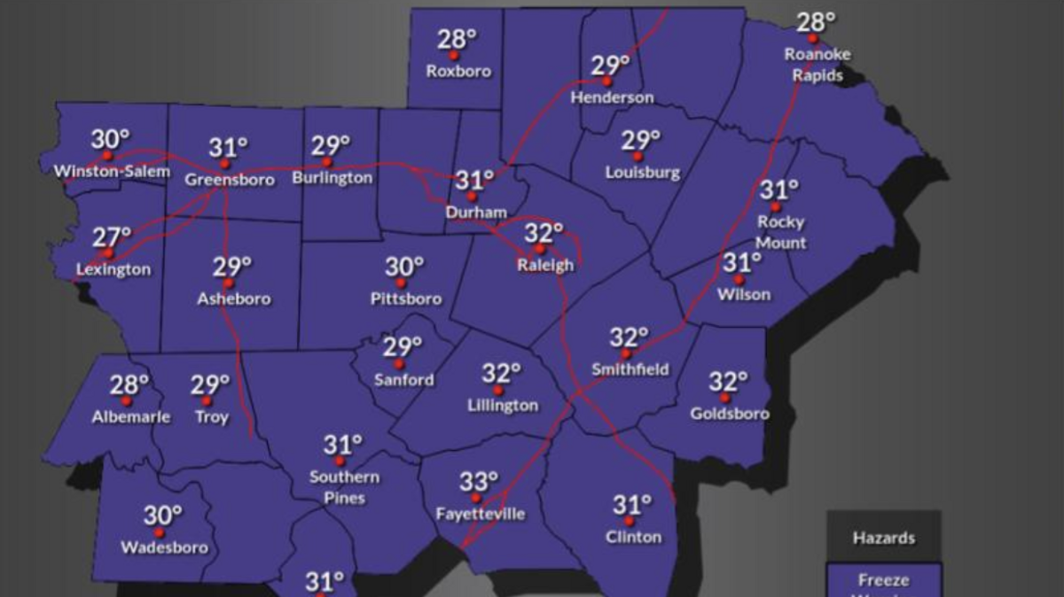
Temperatures in central North Carolina are plummeting this weekend, and the entire region will see temperatures below freezing late Saturday night into Sunday morning.
Read more Georgia reveals UNC men’s basketball’s ‘bad habits’ in season’s first loss
Temperatures will be in the low to mid-30s in the Triangle, dropping to as low as 25 degrees in the western Piedmont, according to a Saturday, Nov. 14, briefing from the National Weather Service’s Raleigh office.
“If you didn’t get to freezing this morning, you almost certainly will tonight, because temperatures are going to be several degrees colder,” said Dan Leins, a meteorologist with the National Weather Service’s Raleigh office. “We’ve got mid-20s across the western Piedmont, like the Triad area. Here in the Triangle, it’ll be right around freezing, maybe 31 or 30 degrees.”
A freeze warning, meaning temperatures will be at or below 32 degrees, is in effect from 1-8 a.m. Sunday, Nov. 15, across much of the Triangle.
The lowest temperatures will be seen in the western Piedmont, where temperatures will drop to the low to mid-20s, Liens said. However, because temperatures in that area already dropped below freezing Friday night, it won’t be included in Saturday’s freeze warning, as the NWS doesn’t issue such warnings if the majority of sites in a given county have reported below-freezing temperatures for multiple days in a row.
Ahead of low temperatures Saturday night, people should cover sensitive plants, make sure any outdoor pets are safely indoors, and shut off any garden hoses or other outdoor pipes to prevent freezing, Leins said.
“Plants, pets and pipes are the three things that we usually talk about with freeze warnings like this,” he said.
Read more NC State chancellor reacts to hazing at Sigma Nu fraternity: ‘It’s deplorable’
No, there are no local forecasts for snow or ice in the Triangle. But that’s not the case for some other parts of North Carolina.
The highest elevations in North Carolina’s mountains, near the Tennessee border, began seeing snow early Friday morning.
“In the far western part of the state, almost on the Tennessee line, there’s a couple spots out there where folks reported anywhere from two to four inches of snow,” Leins said.
Most of that snowfall has been concentrated on the western slopes of the Smoky Mountains. Slightly farther east, Asheville isn’t expected to accumulate any snowfall this weekend, though areas in and around the city have seen flurries over the past 24 hours.
This story was originally published November 13, 2026 at 10:53 AM with the headline “Temperatures to plummet in the Triangle. When to expect frost and freeze.”
Read more For the first time since 1998, South Carolina elects a Democratic U.S. senator