
AI-generated summary reviewed by our newsroom.
Heavy rain, with possible flooding and severe thunderstorms, is forecasted for central North Carolina as the Triangle is under a flood advisory through Thursday.
Read more Expect heavy traffic on these Raleigh roads for Noah Kahan, Guns N’ Roses shows
“Waves of showers and thunderstorms with heavy rain will focus along a slow-moving cold front and produce 2 to 4 inches of rain, with locally higher amounts, (Wednesday) evening through Thursday evening,” according to the flood watch from the National Weather Service.
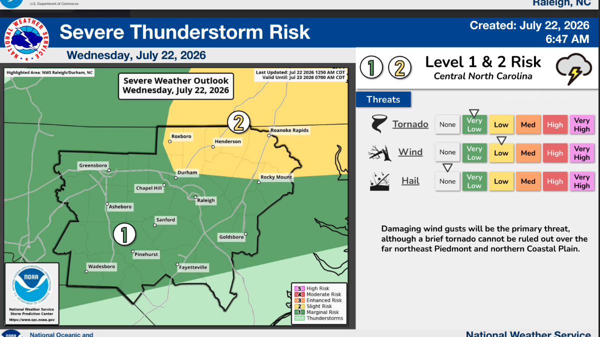
All of central North Carolina, including the Triangle, is under a Level 1, or marginal, risk of severe weather on Wednesday, July 22, according to the National Weather Service.
Some northern areas, including half of Durham County and most of Person, Granville and Vance counties, have a Level 2, slight, risk for severe storms.
“Waves of repeated showers and storms with heavy rain will focus along a front that will edge very slowly southward and into the northern Piedmont and northern Coastal Plain through tonight,” according to the National Weather Service’s Raleigh office. “While locally damaging thunderstorm wind gusts will be the primary severe threat, a brief tornado cannot be ruled out in and immediately adjacent to the Slight risk (Level 2 of 5) area.”
Most storms will arrive in the Triangle in the evening Wednesday night and into early Thursday morning. Raleigh is forecasted to get 2 inches of rain by 8 a.m. Thursday, 1-1.5 inches on Thursday and another inch on Friday, according to the National Weather Service. That’s on top of 2 inches Raleigh saw over the last three days.
Read more Feds investigate ECU med school admissions, citing alleged racial discrimination
“In addition to the heavy rain threat, there is also a risk for severe thunderstorms this afternoon through tonight,” according to the National Weather Service on Wednesday. “Straight-line wind damage and resulting downed trees and power outages will be the most likely hazard and impact. This can happen anywhere across central NC, but most likely across the northern half of central NC (along and north of the Highway 64 corridor).”
While helpful to alleviate the statewide drought, heavy amounts of rain in a short time can cause flooding.
“If you get into those 1-to-2 inch per hour rates, that’s oftentimes what sets the stage for flash flooding,” said Nick Petro, warning coordination meteorologist with the National Weather Service’s Raleigh office. “If you can get 2-to-4 inches of rain over several hours, then that’s less likely to result in flash flooding compared to 2 inches over one hour. So again, rates oftentimes drive flash flooding.”
People should not drive through flooded water, as just a few inches of water can stall a car.
“Any storms that develop will be slow moving, highly efficient rainfall producers and coupled with the potential for storms to continue to develop over the same areas,” according the North Carolina Emergency Management.
Read more William Shatner, 95, and Daughter, 61, Fought Stage 4 Cancer at Same Time