AI-generated summary reviewed by our newsroom.
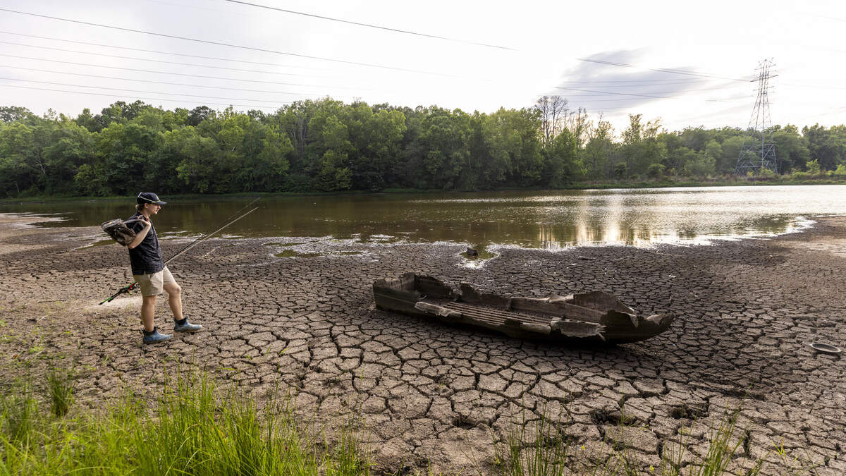
The Triangle’s persistent drought shows its cruelest impact near the west end of Falls Lake: a moonscape of cracked mud, where great blue herons wade in puddles.
Read more NC budget would give raises to officers — and cut hundreds of vacant positions
Take Little Lick Creek, where the Mountains-to-Sea Trail carries hikers along a boardwalk through a pool shin-deep, stretching hundreds of yards in either direction.
On Monday, those hikers watched deer graze in an empty field.
“I was out here last July,” said Landon Olerud, 17, of Wake Forest, standing on the boardwalk, “and this bridge was underwater.”
As drastic as the scenery can be on the lake’s western end, it can look like barely touched closer to Raleigh — creating a deceptive picture of how bad the Triangle’s “exceptional drought” has gotten.
Bass boats are still launching at the Barton’s Creek ramp, reporting depths up to 20 feet.
Hikers are still walking the Falls Lake Trail and coming back satisfied: “It’s still really green,” one reported this week.
Judging the drought by the lake it is draining depends on where you stand.
The topography of the Triangle puts the deepest water around the Falls Dam and shallower toward Durham, giving a misleading idea of its severity.
“There’s people who cross the I-85 bridge and say, ‘Oh gosh, we’re in trouble,’” said Ed Buchan, assistant director for Raleigh Water. “But up N.C. 50, near the dam, if you’re not familiar, it looks the same way.”
Falls Lake measured 244.95 feet Tuesday, more than 5 feet below its target level, thanks to rainfall shortage now at roughly 12 inches over the last year.
The drought has struck nearby Jordan Lake, though not as drastically, and most of all the rivers and streams that feed them.
Read more NC could ditch physical car registration cards and stickers under budget plan
“This drought is getting worse and worse,” wrote Duke University professor Kent Wicker, posting pictures of a dry creek bed on Facebook. “Below are pictures of Seven Mile Creek, the nearest to my house. In the past, it has had duck families and beavers in it.”
But for most of Raleigh, the drought’s impact is limited to Stage 1 restrictions, which limit when and where lawns and plants can be watered — not even as strict yet as those set in 2008.
Its full impact is harder to gauge for Raleigh because the water remains deeper closest to Falls Dam.
The further it backs up toward Durham, forming finger-like coves, the more shallow it gets.
“Up past I-85,” Buchan said, “it gets very shallow even when it’s full.”
On top of this, Buchan said, Falls Lake is theoretically divided in two — just not by an actual wall.
Of its water, 58% is reserved for Raleigh’s drinking supply; the rest is set for downstream releases, moving down the Neuse River toward Smithfield and Goldsboro.
Of the roughly half reserved for Raleigh: 64% remains.
So along the Falls Lake banks, anglers still toss a line into the water hoping to hook a fish.
Paddlers still float kayaks and boaters still speed past spraying water in the air.
Read more Elon University is now in control of Queens in Charlotte, accreditor says
But that pool is rapidly shrinking, whether we see it or not.
This story was originally published June 30, 2026 at 3:58 PM.